


Precision GPS Free
Deskripsi Precision GPS Free
'Precision GPS Free' uses your device's GPS sensor to measure your location more accurately than is possible with typical GPS apps. Turn your phone or tablet into a precision GPS instrument.
Normally, software on your Android device determines your location from individual GPS readings. This is fine if your are interested in getting your location to within about 10 meters. However, it is possible to do better than this if you average many readings at a particular location.
This app is designed to do just that -- average many readings of a stationary Android device to get a more accurate location; it actually calculates a weighted average, accounting for the accuracy of each reading. The trade-off is time. You will need to wait a least a few minutes to get a high accuracy average location.
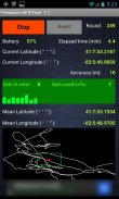
'Precision GPS Free' displays the following information on the main screen:
-'start/stop' button,
-'reset' button,
-battery power remaining as percentage,
-current latitude and longitude,
-round number,
-elapsed time,
-number of GPS satellites in view,
-number of GPS satellites employed in fixing location,
-signal-to-noise ratio of signal from each satellite,
-accuracy of the current readings,
-weighted average (mean) latitude and longitude,
-graph of the current latitude and longitude (white connected points) and the average value (red dot),
-bounding 'scale box' (green) around mean position with a width and a height of 2 meters.
The reset button is inactive while readings are being taken. It can be used after the 'stop' button is pressed. If the measurements are stopped and then started again without pressing the reset button, then only the 'elapsed time' value is reset.
The latitude and longitude values are shown on the graph. North is towards the top and east is toward the right, as in a map. The graph automatically rescales to include the extreme values of longitude and latitude each time it updates the graph (every four seconds). The green scale box is not always square in shape, since the graph latitude scale is not necessarily the same as the graph scale in longitude.
The app times out after 30 seconds if the device cannot get a satellite fix.
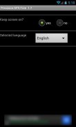
A 'settings' screen provides an option to keep the screen continuously on while the app is running.
Localization language support is provided for French, German, and Spanish.
This app does not save or transmit any personal information, including location or pictures. All the required permissions relate to the GPS operation and the ads.
Applications of 'Precision GPS Free' include navigation, geocaching, prospecting, emergencies, surveying a property, observational astronomy, and archaeology.
A pro version of this app is also available, called 'Precision GPS Pro'. It adds elevation and HDOP, PDOP, VDOP data and options to save the location (and copy to the clipboard), change the interval that readings are taken, display UTM coordinates, display a sky map of the active satellite positions, run in the background, change the format of the coordinates, and send the average coordinates to a mapping app, such as 'Google Maps.' The pro version is also ad-free.
If you have any suggestions for improvements or problem reports, please contact us at ggonzo47@gmail.com.
'Presisi GPS Gratis' menggunakan perangkat Anda sensor GPS untuk mengukur lokasi lebih akurat daripada yang mungkin dengan khas aplikasi GPS. Hidupkan ponsel atau tablet menjadi instrumen presisi GPS.
Biasanya, perangkat lunak pada perangkat Android Anda menentukan lokasi Anda dari individu pembacaan GPS. Ini bagus jika Anda tertarik untuk mendapatkan lokasi Anda untuk jarak sekitar 10 meter. Namun, adalah mungkin untuk melakukan lebih baik dari ini jika Anda rata-rata banyak bacaan di lokasi tertentu.
Aplikasi ini dirancang untuk melakukan hal itu - rata banyak bacaan dari perangkat Android stasioner untuk mendapatkan lokasi yang lebih akurat; itu benar-benar menghitung rata-rata tertimbang, akuntansi untuk akurasi masing-masing membaca. Trade-off adalah waktu. Anda harus menunggu setidaknya beberapa menit untuk mendapatkan rata-rata akurasi tinggi lokasi.
'GPS Presisi Gratis' menampilkan informasi berikut pada layar utama:
-'start / stop 'tombol,
-'reset 'tombol,
listrik -Baterai tersisa sebagai persentase,
lintang dan bujur -current,
-round nomor,
-waktu berlalu,
-Jumlah satelit GPS dalam pandangan,
-Jumlah satelit GPS yang digunakan dalam memperbaiki lokasi,
rasio -signal-to-noise dari sinyal dari setiap satelit,
-accuracy dari pembacaan saat ini,
rata -weighted (rata-rata) lintang dan bujur,
-graph garis lintang dan bujur saat (poin terhubung putih) dan nilai rata-rata (red dot),
-bounding 'kotak skala' (hijau) sekitar posisi rata dengan lebar dan tinggi 2 meter.
Tombol reset tidak aktif sementara angka yang diambil. Hal ini dapat digunakan setelah tombol 'stop' ditekan. Jika pengukuran dihentikan dan kemudian mulai lagi tanpa menekan tombol reset, maka hanya 'waktu berlalu' nilai-reset.
Lintang dan bujur nilai-nilai yang ditampilkan pada grafik. Utara ke arah atas dan timur adalah ke kanan, seperti dalam peta. Grafik secara otomatis rescales untuk memasukkan nilai-nilai ekstrim bujur dan lintang setiap kali update grafik (setiap empat detik). Kotak skala hijau tidak selalu persegi dalam bentuk, karena skala grafik lintang belum tentu sama dengan skala grafik di bujur.
Aplikasi kali keluar setelah 30 detik jika perangkat tidak bisa mendapatkan sinyal satelit.
Layar 'pengaturan' menyediakan pilihan untuk menjaga layar terus-menerus pada saat aplikasi berjalan.
Dukungan bahasa lokalisasi disediakan untuk Perancis, Jerman, dan Spanyol.
Aplikasi ini tidak menyimpan atau mengirimkan informasi pribadi apapun, termasuk lokasi atau gambar. Semua izin yang diperlukan berkaitan dengan operasi GPS dan iklan.
Aplikasi 'Presisi GPS Gratis' termasuk navigasi, geocaching, calon, keadaan darurat, survei properti, astronomi observasional, dan arkeologi.
Sebuah versi pro dari aplikasi ini juga tersedia, disebut 'Presisi GPS Pro'. Ia menambahkan elevasi dan HDOP, PDOP, data VDOP dan pilihan untuk menyimpan lokasi (dan copy ke clipboard), mengubah interval yang pembacaan diambil, layar UTM koordinat, menampilkan langit peta posisi satelit aktif, berjalan di latar belakang , mengubah format koordinat, dan mengirim koordinat rata-rata untuk aplikasi pemetaan, seperti 'Google Maps.' Versi pro juga bebas iklan.
Jika Anda memiliki saran untuk perbaikan atau laporan masalah, silahkan hubungi kami di ggonzo47@gmail.com.
Precision GPS Free - Versi 2.1
(17-12-2018)Precision GPS Free - Informasi APK
Versi APK: 2.1Paket: com.sciencewithandroid.precisiongpsfreeVersi Terakhir dari Precision GPS Free


Aplikasi pada kategori yang sama


Anda juga mungkin suka...


